Issue 1/2015 - Kritische Netzpraxis
SINUNI
Exploring an Open Circumpolar Knowledges, Data Gathering, Dissemination and Sharing Network
The circumpolar Arctic cultural, ecological, geophysical, geopolitical and socio-economic zones are recognized as one of the most dynamic components of planetary systems that are undergoing extreme transformation in a multitude of interconnected domains. The cultures that inhabit these zones form an integral part of these transformative processes through constant adaptation that is integral to their survival and thriving. With the 2007-2009 International Polar Year (IPY) and its mandate to include these cultures as important and in many cases central nodes of research collaboration and execution, a multitude of projects and initiatives have been started that aim at the pro-active involvement of local and traditional knowledge (LTK) and community-based monitoring (CBM) paradigms in research activities with the particular focus on LTK data management. IPY projects such as the ongoing Exchange for Local Observations and Knowledge of the Artic (ELOKA) complex, the Inuit Sea Ice Use and Occupancy Project (ISIUOP), the Reindeer Herders Vulnerability Network Study: Reindeer Pastoralism in a Changing Climate (EALÀT), the Circumpolar Flaw Lead - Team 10 (CFL T10) all include a substantial involvement of LTK and CBM and provide a solid basis for further methodological development that leads towards an integral participatory inclusion of traditional knowledges (Van Der Velde, 2010). One of the IPY projects that later formed the basis of the Arctic Perspective Initiative (API) development was the Interpolar Transnational Art Science Constellation (I-TASC, IPY 419), which was based on principles of participatory and open cultural, artistic, scientific, tactical media and technological exchanges on an interpolar (North/South) basis. The experiences in developing and deploying open technology systems, from community operated FM radio setups to long distance weather sensor networks in Antarctica and community discussions and consultations about autonomous communications and mobile habitation systems in Nunavut during the IPY, formed a solid basis for the establishment of the Arctic Perspective Initiative, an artist run long term program of engagement with the northern circumpolar cultural and natural ecosystems. From 2009-2014 among other activities, API spearheaded the development of the SINUNI open mobile data gathering network devices and tested them in limited conditions in the field in Nunavut and Lapland. The SINUNI is an extremely low power, compact, modular and waterproof portable computing and recording family of devices, based on the Arduino architectures implementing a true mesh networking capability through low power radio and precise geo-location. It’s modular sensor architecture records basic meteorological, position and movement data, but it can be outfitted with an array of sensors as diverse as water turbidity, temperature, salinity and p.e. light quality and structure measurements. The open standards used in the software and hardware development ensure that the system can be built, modified and replicated in the North. The units also enable geo-located audio recording and wildlife observations and note taking through a simple, robust and intuitive interface.
Sinuni experimental node Gen.2
During the fieldwork in the Foxe Basin, the Fury and Hecla straits area and Lapland large amount of environmental, wildlife observation and traditional placenames and trail data was collected. Besides the SINUNI, API has deployed fixed wing unmanned aerial vehicles (BRAMOR UAS) to create orthophoto and terrain maps of the observed areas.
BRAMOR UAS in KILPISJAERVI, 2012
SINUNI network topologies
The SINUNI system enables instant review of the collection in the field, but more importantly, its mesh architecture enables a seamless transfer of data and network bridging between the different units without any specific inputs from the users, leaving them free to concentrate on the work on the Land. The geo-locative approach to all data and sound recording gathering facilitates the creation of quick reference maps with audio annotations and the entry of the data in GIS systems. The main goal of the project at this stage is to enable a true collaborative engagement of indigenous field citizen scientists, possessing raw data and traditional knowledge entries, with the Arctic science complex, where the ownership and provenience of the data is clearly connected to work and life on the Land and can be freely shared between and understood by the communities. A larger future collection saturation and the creation of a display system for data sharing and distribution in several Arctic languages is envisaged. The goal of the SINUNI program is to collect the results and create case studies for each community and to explore the potentials for building such a network of hybrid audio/visual sensor based hardware, combined with a database and management program that is flexible enough to serve varied communities yet continues to enable interoperability.
SINUNI system workflow and archive building protocol
These results will be published within the “Arctic Perspective Cahier series” though a ‘book sprint’ paradigm. The book will include maps created, data collected and vetted by the communities, as well as examples and instructions for using the demonstration systems. The publications and manuals will be printed in the local languages of the locations as well as English, and be made available via PDF and print, under a creative commons license.
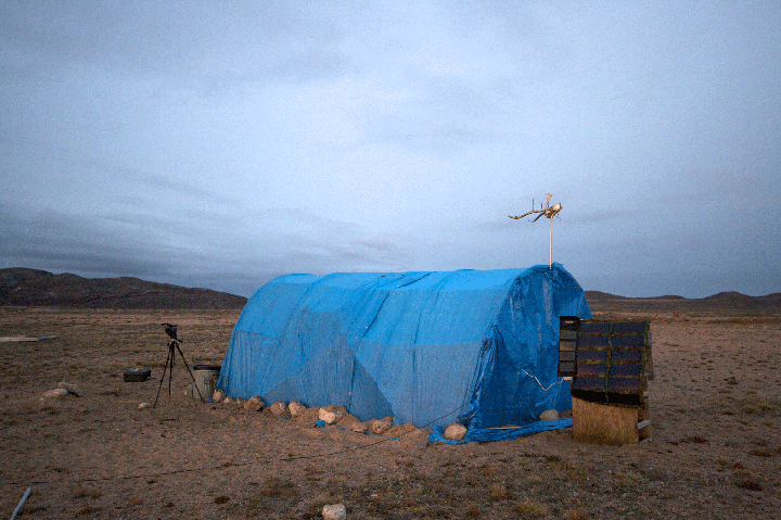
SINUNI on the land (Nunavut)
Since the contextualization of these activities is of utmost importance and the notion of the CONTACT ZONE and KNOWLEDGES has to be introduced at this point in time, we are hereby reprinting the article DESIGN FOR THE CONTACT ZONE by Maja Van Der Velden, which in our opinion presents a perfect lens through which to reflect the current API activities and endeavors.
SINUNI generated map with local and traditional placenames


